


by Dennis Dalman
news@thenewsleaders.com
The long-anticipated drawdown has finally begun.
The Mississippi River north of Sartell and Little Rock Lake near Rice are now 3 feet lower than they were July 31.
At midnight Aug. 1, the Sartell hydroelectric dam was opened gradually to let massive amounts of water flow down river, lowering the water levels in the lake and the river, which are connected via the Harris Channel. The lowering process took about 30 hours.
The drawdown is expected to increase the water quality of Little Rock Lake and parts of the river. It was supposed to happen one year ago but had to be delayed because of regulations and other factors.
The water level will remain 3 feet lower until Sept. 14, at which time the dam will begin to hold back water, restoring it and the lake to former levels.
About 700 acres of lake bed and river bottom will be exposed to air and sunlight during the drawdown. The drawdown project involved the plantings of 45,000 aquatic plants, known as “emergents,” by volunteers on the exposed areas of the lake bottom. Most of the volunteers are members of the Little Rock Lake Association, as well as Boy Scouts. The emergents, once fully established, will be able to absorb as food the excess nutrients in the lake, thus helping keep the water cleaner and clearer. The plants will also provide habitat for fish and birds.
The following are advisories as suggested by the Department of Natural Resources and drawdown project coordinator Eric Altena of the DNR Little Falls Fisheries Division:
A no-wake zone is in effect for the river up to the Rice bridge, the Harris Channel area and Little Rock Lake. That is necessary so that boat-made waves do not wash onto the exposed areas, which must dry out with exposure to air and sunlight.
The water in the lake and river is navigable for boats, but boaters should be on a careful look-out for objects sticking up that may have been covered by water before the drawdown.
Public accesses are still open, and the DNR is doing upkeep maintenance on them.
It is illegal to drive vehicles on exposed areas of the river or lake.
Residents are allowed to remove litter and junk from the exposed areas of lake and river, but they should leave natural items such as branches or wood in place because they are good for fish habitat.
Residents should avoid digging in the exposed sediment.
The unpleasant odor of rotting vegetation is expected to wane in time as the drawdown continues.
Background
For many years, blue-green algae growth caused by run-off nutrients (phosphorous, nitrogen) made the water of Little Rock Lake murky and unhealthy for people, fish and animals. The lake is 2.27 square miles in size with an average depth of 8 feet.
In the past, various remedies were attempted with the goal of reducing undesirable nutrients that cause algal blooms. Such attempts included alternate farming methods in the watershed area, irrigation, manure management and septic-system upgrades. Those remedies helped somewhat. In time the lake problems became so bad the lake was not clean enough for swimming, foul smelling and so filled with algae that it could actually kill a dog that would wander into the water.
The drawdown, the DNR explained, is actually a kind of artificial man-made drought. For thousands of years, the Mississippi River underwent natural drought cycles that would kill off undesirable vegetation and create stability in sediments. But river dams changed all that, interfering with the natural cycles or water-and-droughts. The Sartell dam was constructed in 1907. That caused the Little Rock Lake area, which was just a stream-fed watershed basin, to fill with water, raising its level and creating a lake there.
Other issues
The DNR has received many questions from residents about whether they can make shoreline improvements during the drawdown, such as placing rip-rap (rocks) along shorelines. For most improvement projects, an alteration permit would be required. People are advised to call the Sauk Rapids Area DNR Office with permit questions at 320-223-7840. Many other permit questions can be answered at the following website: www.dnr.state.mn.us/permits/water/needpermit
Other general questions can be handled by calling 320-616-3450, ext. 225 or emailing eric.altena@state.mn.us.
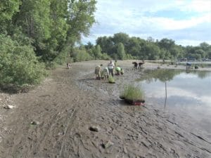
After the Mississippi River and Little Rock Lake were lowered by 3 feet, this mud flat was exposed by Benton Beach Park. Planters (background) were busy putting in aquatic plants on the morning of Aug. 3.